Published at
Tâmpa - Adventure and Relaxation near Brașov
Tâmpa – Brașov is a love story: the city almost wraps around the mountain, like an embrace, while the mountain proudly displays the city’s name in glowing letters, declaring its affection far and wide. From the top of Tâmpa, you get a breathtaking view of Brașov and the surrounding lands of Ţara Bârsei. Whether you choose to hike (the path isn’t difficult) or take the cable car, reaching the peak is worth it to enjoy the stunning landscapes and uncover its hidden treasures.
The story of Mount Tâmpa
Mount Tâmpa is part of the Postăvaru massif and is predominantly composed of limestone formations created by the folding of the Earth’s crust. Its story is closely tied to the history of Brașov: like the city, the mountain has been ravaged by fires and scarred by communist rule. Between 1950 and 1960, the city bore the name of Stalin, and the Soviet-imposed regime in Bucharest marked the dictator’s name across a bare hillside, spelling it out with rows of fir trees. Just like Brașov, Tâmpa rebelled; those fir trees were long gone, overtaken by other trees.
The mountain’s highest point rises to 960 meters above sea level, and nearly 400 meters above the city’s ground level. Covering an area of 150 hectares, Tâmpa is home to a valuable nature reserve, rich in unique landscapes, wildlife, and plant species.
Etymology – where did the name originate
Sextil Pușcariu reflected on the name Tâmpa: “How is it that the Romanians, who typically give such vivid names to their mountains, like Omul, Babele, Strunga, and others found in the nearby Bucegi range, would have chosen such an unsuitable name here, one that reminds us of the words ‘tâmp’ and ‘tâmpit’ (which mean dull or foolish)?” The scholar agreed with Nicolae Drăganu’s theory that the original meaning of Tâmpa refers to a steep cliff, and that the word is ancient, dating back to pre-Roman times in the region of Romania. It is also found in similar forms among the Albanians in Calabria and in certain Italian dialects. The cliffs of Tâmpa Mare and Tâmpa Mică at the top of the mountain may serve as evidence supporting this hypothesis.

How to reach Mount Tâmpa from Brașov
You can reach the top of the mountain by taking the cable car or by hiking one of the trails that start at various points in the city. The trails are no longer than 2.7 kilometers, have low difficulty levels, and are well-marked. If you choose to hike up and/or down, make sure you have proper hiking gear. The ascent takes about an hour and a half, while the descent takes roughly an hour.
Hiking trails from Brașov to Tâmpa
From Brașov you can choose from several trails that lead to the top of Mount Tâmpa. Two of the most popular ones are the Serpentine Road and Gabony’s Stairs. Both are easy to follow (just make sure to wear proper footwear), beautiful, and well-marked, so you won’t risk getting lost. The Serpentine Road is 2.7 kilometers long, while Gabony’s Stairs are 1.7 kilometers.
Brașov – The Serpentine Road – Tâmpa Peak
The Serpentine Path begins at Aleea Tiberiu Brediceanu no. 1, near the cable car station.
- Marking: red triangle;
- Trail length: 2.7 kilometers;
- Difficulty: low, but appropriate hiking footwear for the season is required. The path winds uphill in a series of switchbacks towards the mountain summit;
- Estimated hiking time: about one and a half hours, plus stops along the way. You’ll want to take breaks to enjoy the views and snap some photos.
Brașov – Gabony steps – Tâmpa Peak
The Gabony Steps trail starts at 62 Constantin Dobrogeanu-Gherea Street.
- Trail Marking: Yellow triangle;
- Length: 1.7 kilometers;
- Difficulty: Easy, but steeper than the Serpentine Road. To navigate it comfortably, be sure to wear suitable hiking shoes for the season;
- Estimated ascent time: Around an hour and a half, plus however long you wish to take for breaks to enjoy the scenic views and capture photographs of everything that catches your eye.
Hiking trails recommendation
Tâmpa Mountain Circuit: Bastionul Țesătorilor – Drumul Cavalerilor – Șaua Tâmpei – Tâmpa Peak, return via the Serpentine Road
Starting point: Bastionul Țesătorilor in the center of Brașov. Follow the blue stripe trail (Drumul Cavalerilor) up to Șaua Tâmpei, and from there, continue on the yellow triangle-marked trail to Tâmpa Peak. For the return, take the Serpentine Road, marked with a red triangle. There are plenty of signs along the way to help you navigate.
- Distance: 6 km;
- Duration: 3 hours (including a few short breaks);
- Difficulty: The trail to Șaua Tâmpei is quite steep. If you’re not in great shape, it might be a bit challenging, but it’s not dangerous;
- Attractions: Along the way, you’ll pass the Brașovia Fortress, which remains in ruins. Follow the yellow triangle markers to reach Tâmpa Peak, offering breathtaking views of the Piatra Craiului Mountains, Măgura Codlei, and the Perșani Mountains. Then, descend a little and you’ll reach the iconic Brașov letters; from here, you’ll have a stunning view over the city.
Brașov – Tâmpa – Postăvaru Peak (Postăvaru Cabin) – Solomon’s Rocks – Schei District Circuit
- Difficulty: Moderate, though some sections are steep and you’ll need to hold onto metal bars mounted on rocks;
- Distance: 27 km;
- Duration: 8 hours walking (you can shorten the trip by taking the cable car up).
Start by climbing to Tâmpa Peak via the Serpentine Road (red triangle) or the Gabony Steps (yellow triangle). From there, take the blue stripe-marked trail, descend to Șaua Tâmpa, and then continue to Postăvaru Peak, passing through the Crucurul Mare Peak and Poiana Ruia. Along the way, you’ll find Postăvaru Cabin, where you can stop for a meal or relax on the terrace. It’s about a 30-minute walk to Postăvaru Peak from the cabin, continuing on the blue-marked path. The trail becomes steeper, with slippery rocks, so you’ll need to use the metal bars for support.
From Postăvaru Peak, descend to the cable car station, then take a steep, unmarked trail towards the lake in Poiana Ruia. From there, follow the blue stripe trail until you reach the junction with the yellow band-marked trail leading to Solomon’s rocks. This section is steep and rocky. The circuit ends at the paved road leading to the Șchei district, where you can either take the bus to the city center or walk through the charming neighborhood to admire the historic buildings.
The legends of Mount Tâmpa
The Dacians, Romans, and Teutonic Knights. According to some sources, the Dacians are believed to have had sacrificial altars on Mount Tâmpa. It is said that the Romans discovered these altars and dedicated them to Saturn, the god of time, calling them Tempus/Temporis, which is thought to be the origin of the name Tâmpa. However, this theory has been dismissed by experts. The theory continues with the Teutonic Knights, colonists sent by the Kingdom of Hungary, who allegedly translated the name of Cronos into their native German as “Kronos,” shortened it to “Kron,” and added the suffix “Stadt,” meaning city. Therefore, Kronstadt actually means “City of the Crown,” referring to the Hungarian crown.
Other legends are even more fascinating, such as the one about the lake hidden in the mountain’s womb and the story of the stone bench.
The lake in the bowels of the mountain
It is said that a gigantic lake lies inside the Tâmpa Mountain. Before World War II, the authorities planned to dig a tunnel through Tâmpa to connect the old center of Brașov with the Valea Cetății neighborhood. However, the idea was abandoned due to the war. In 1979, the communist regime revived the project, aiming to build a tunnel parallel to Dobrogeanu-Gherea streets and Tâmpa. After excavating about 100,000 cubic meters of rock, the construction managers realized that completing the tunnel would be unjustifiably expensive. Additionally, if the legend turned out to be true, drilling through the mountain’s walls could have caused flooding in the city.
The Bank carved into the rock
Underneath Tâmpa Mountain, there is a bench carved from a stone block. According to a legend mentioned in a document from 1817, it was sculpted in memory of Ana-Maria and her lover, who are said to have died embraced under the weight of a boulder that rolled down from the top of the mountain. The simple beauty of the bench, believed to have been carved from the very stone that caused their tragic end, combined with the romantic story of the young lovers, has turned the spot into a popular attraction for both locals and tourists.
Tourist attractions in Tâmpa
On Tâmpa Mountain and its base, there are many tourist attractions to explore. Beyond the numerous viewpoints offering breathtaking landscapes and the natural beauty of the reserve, you’ll also find several interesting landmarks to see and photograph, including the iconic “Brașov Sign” (the letters spelling out the city’s name), the Knifemakers Tower, the Shoemakers Tower, and the Forest Ranger’s Lodge, among others.
The sign of Brașov
The inscription on Mount Tâmpa was first installed in 2004 by local authorities, but the letters weren’t strong enough to withstand the weather conditions. In 2006, the “Brașov Sign” was rebuilt with 6-meter-high letters equipped with high-power lights. The sign is visible from several dozen kilometers away, along the roads to Târgu Secuiesc, Târgu Mureș, and Sibiu. It has become one of the most visited landmarks in Brașov and is located just a few minutes below the mountain’s highest point, Tâmpa Peak. Nearby, you can find the Panoramic Restaurant, which truly lives up to its name thanks to the stunning views it offers.
Tower of the Knifemakers
In the 15th century, two watchtowers were built at the base of Tampa Mountain: the Tower of the Knifermakers and the Shoemaker’s Tower. These towers were connected by a wall that stretched from the city and rose up towards the peak of the mountain. However, after the advent of firearms, both structures were abandoned and eventually demolished.
The Knifemakers Tower was located near the Weavers’ Bastion, and from there, one could observe the Șchei area, which was not protected by the city’s fortification walls. Unfortunately, no trace of the tower remains today.
The Shoemakers’ Tower
The Shoemakers’ Tower was situated above the Postavaru Bastion. From its peak, the guards kept watch over Blumăna (which was not enclosed by the city walls) and the Curmătura area (the region between Tâmpa and the Hill of Snails). Only the base platform and a section of the wall that extended from here towards the Tâmpa Peak remain from the old structure.
Chalet-restaurant the Forester’s House
The restaurant of Forester’s House was built in the early 20th century, located along the promenade under Tampa Mountain, very close to the cable car station. After being damaged by a fire, the building was recently renovated. The restaurant features a spacious terrace and rustic decor. It’s worth visiting, if only to enjoy the stunning natural surroundings and the beautiful view of the city.
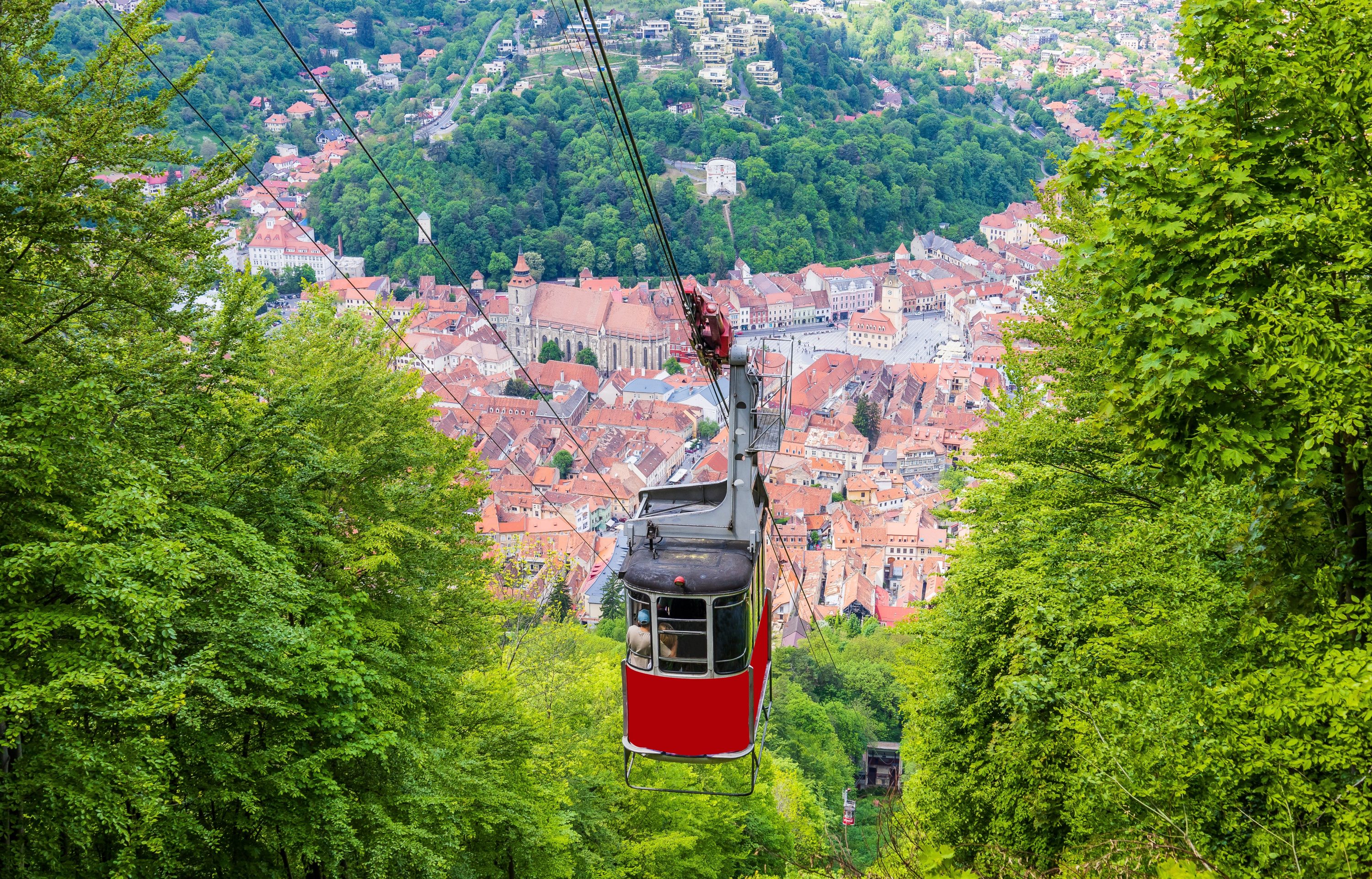
Schedule and rates for the cable car
The Tâmpa Cable Car station at the base is located in the historic center of Brașov, next to the restaurant of Forester’s House. The journey to the Panoramic Restaurant station at the top of the mountain takes 3 minutes.
Schedule:
- Monday: Maintenance day.
- Tuesday to Sunday: The first ride up is at 9:30 AM, the last ride up is at 4:00 PM, and the last ride down is at 4:30 PM.
Ticket Prices:
- One-way (up or down): 25 RON/adult, 15 RON/child;
- Round trip (up and down): 35 RON/adult, 20 RON/child.
Tickets can only be purchased at the stations (not online), and payments can be made by cash or card.
Where to stay? Choose the Transylvanian Inn for an authentic spiritual experience!
If you’re planning to visit Brașov and the surrounding areas, including Bran Castle, Peleș Castle, fortresses, fortified churches, Viscri (“Prince Charles’ village”), and many other attractions in Transylvania, we recommend staying at Transylvanian Inn.
The rooms are spacious, comfortable, and elegantly decorated, each featuring a terrace or balcony with stunning views of Bran Castle, Râșnov Fortress, the Bucegi Mountains, and Piatra Craiului.
Transylvanian Inn is located in a peaceful and charming spot in the village of Predeluț, Bran, just 2.3 km from Bran Castle. The property offers a generous garden with a pond, a campfire area, pavilions, and shaded spots. The top floor of the building features a library with panoramic windows, allowing you to enjoy breathtaking landscapes. The restaurant, with its terrace, is highly praised by visitors for its exceptional dishes, which you can enjoy either indoors or on the terrace.
To make a reservation, visit https://transylvanianinn.ro/.